![]()
![]()
![]()
![]()

RI Coastal Resources Management Council
...to preserve, protect, develop, and restore coastal resources for all Rhode Islanders
![]()
![]()
![]()
![]()
...to preserve, protect, develop, and restore coastal resources for all Rhode Islanders
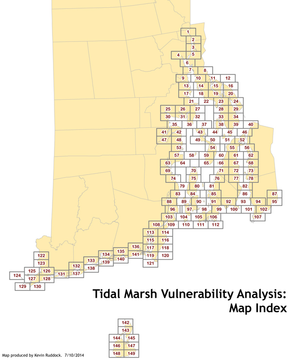
The Rhode Island Coastal Resources Management Council (CRMC) and its partners have developed Sea Level Affecting Marshes Model (SLAMM) Maps for the coastal wetlands of all 21 Rhode Island coastal communities. The purpose of these SLAMM maps is to show how coastal wetlands will likely transition and migrate onto adjacent upland areas under projected sea level rise scenarios of 1, 3 and 5 feet in the coming decades. These maps are intended to support state and local community planning efforts and to help decision makers prepare for and adapt to future coastal wetland conditions despite the inherent uncertainties associated with future rates of sea level rise.
You can click on each individual panel on the map below to view a PDF of the maps for that section or click on the city or town link at the bottom of this page for maps of that entire coastal community. Be aware the files are large (approximately 5-15MB).
Use the Salt Marsh Coastal Parcel Planning Tool to view the coastal parcel database, SLAMM outputs, and all Tier 1 parcels.
Courtesy Mike Bradley, URI, Save the Bay, NBNERR, and the RI Land Trust Council
The SLAMM maps were developed using a digital wetlands coverage derived from the 2010 National Wetlands Inventory for Rhode Island. The elevation data used in the model was developed from the 2011 USGS LIDAR elevation dataset. These maps were developed using the “protection off” mode for the model simulations, thereby depicting the highest potential for marsh migration despite current limitations such as parking lots, roads or other development. In this way the maps illustrate opportunities for conservation and potential land modification to enhance wetland migration and restoration. The SLAMM data do not consider natural processes such as coastal erosion or the impacts of coastal storms that can have significant influence on shoreline location and sediment dynamics. In cases where coastal barriers are shown on maps, they will be cross-hatched and identified as “CRMC Coastal Barriers.” Due to the model limitations with barrier erosion and sediment transport, there is higher uncertainty of coastal wetland migration accuracy abutting these barriers. Despite these limitations the data still provide a valuable tool to identify those places that provide the best opportunity for future saltmarsh habitat and conservation priorities, and provide valuable information to help plan for new development and infrastructure.
You can view a set of PDF maps for each coastal Town or City by clicking on one of the 21 coastal municipality PDF file links below.
These SLAMM maps are Geographic Information System (GIS)-based map images exported as PDF files to reduce file size and ease of access. In total there are 149 map panels that cover the entire Rhode Island shoreline and each panel has four maps showing the initial (current) wetland condition followed by the 1, 3, and 5-feet of sea level rise scenarios.
SLAMM geographic information system (GIS) shape files are available on the RIGIS web site here: http://www.edc.uri.edu/rigis/data/data.aspx?ISO=oceans.
No warranty is expressed or implied by the CRMC and its SLAMM project partners related to the spatial accuracy of these maps and promote no other use of these maps and data other than as a planning tool. These maps should not be used for, and are not intended for, survey and engineering purposes. The data do not take the place of a legal survey or other primary source documentation. They were created for general reference, informational, planning, and guidance use. They are not a legally authoritative source as to the exact location of natural or manmade features.
These maps may also be examined at the CRMC office in Wakefield.
Stedman Government Center
Suite 116, 4808 Tower Hill Road, Wakefield, RI 02879-1900
Voice 401-783-3370 • Fax 401-783-2069 • E-Mail cstaff1@crmc.ri.gov
![]()
![]()
An Official Rhode Island State Website