![]()
![]()
![]()
![]()

RI Coastal Resources Management Council
...to preserve, protect, develop, and restore coastal resources for all Rhode Islanders
![]()
![]()
![]()
![]()
...to preserve, protect, develop, and restore coastal resources for all Rhode Islanders
Illustrates and displays storm inundation, with and without sea level rise, for different types of storms that could occur along RI’s coast line.
Notice: Temporary Lapse in Storm Tools Web Access
Some of our current StormTools products – specifically the Coastal Hazards Analysis viewer, StormTools Design Elevation maps, and Coastal and Environmental Risk Index - are temporarily inaccessible (see Home page).
In the interim, we encourage folks to continue to use the layers available from Beginner and Advanced StormTools. For Coastal Hazard Analysis Worksheets, please complete all portions that can be filled out as CRMC will still need this information for permit application reviews. Thank you!
Sea Level Affecting Marshes Model (SLAMM) Maps (adopted by the CRMC on January 13, 2015)
CRMC’s James Boyd on the Sea Levels Affecting Marshes Model (SLAMM) Results and Analysis (YouTube)
Rhode Island Sea Level Rise and Storm Surge Maps
CRMC a leader in planning for, addressing sea level rise and climate change concerns in RI
Overview of a Changing Climate in Rhode Island (PDF)
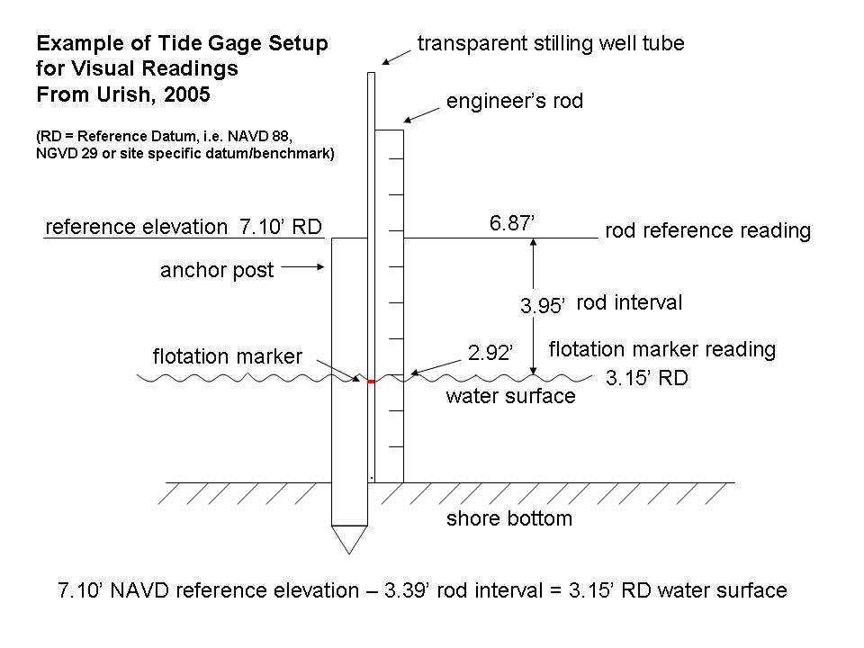
Methods for Short-term Tide Measurements:
Virginia Offers Adaptive Strategies for Sea Level Rise
Risk Reduction for Small Business Resilience
Shoreline Change Special Area Management Plan (SAMP)
Sea Level Trends for Providence RI – NOAA
Sea Level Trends for Newport RI – NOAA
National Climate Assessment, Northeast
Northeast Climate Impacts Assessment (NECIA) – Union of Concerned Scientists
Overview of a Changing Climate in Rhode Island (PDF)
Rhode Island’s Rising Tide: CRMC and RI Sea Grant’s Pam Rubinoff featured in NOAA Climate Magazine
Confronting Climate Change in in the U.S. Northeast
Stedman Government Center
Suite 116, 4808 Tower Hill Road, Wakefield, RI 02879-1900
Voice 401-783-3370 • Fax 401-783-2069 • E-Mail cstaff1@crmc.ri.gov
![]()
![]()
An Official Rhode Island State Website