![]()
![]()
![]()
![]()

RI Coastal Resources Management Council
...to preserve, protect, develop, and restore coastal resources for all Rhode Islanders
![]()
![]()
![]()
![]()
...to preserve, protect, develop, and restore coastal resources for all Rhode Islanders
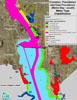
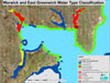
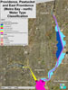
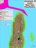
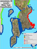
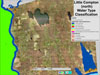
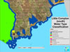
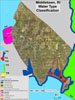
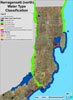
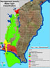
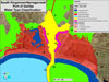
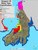
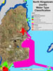
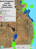
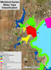
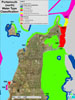
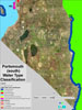
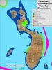
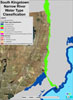
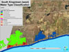
Click on the thumbnails below for detailed maps of water types for that town or city. All files are in PDF format.
Barrington
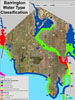
70 – A straight line along the southern bulkhead wall of Lavin's Marina, then straight across the channel to where it meets the spit on the western shore.
71 – A line from the southeastern end of Blanding Avenue running generally southeasterly across the channel to where it meets the end of Willow Way.
72 – A line along the edge of a salt marsh at the end of Appian Way.
73 – The outlet of a small pond and stream south of Beach Road.
74 – The northwestern border of the salt marsh.
75 – A straight line extension of Adam's Point Road.
76 – A straight line extension of the south side of Ferry Lane.
77 – Along the southern side of the old railroad causeway.
78 – Along the westerly side of the Barrington River at the tidal creek entrance.
79 – The tip of the small peninsula at the southern side of Walker Farm, Barrington.
80 – A straight line extension of George Finnerty Road.
81 – Along the southern side of the old railway causeway.
82 – A straight line from the north side of the end of Stanley Avenue running due easterly to a point of land on the opposite shore.
Block Island (New Shoreham)
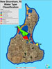
133 – Straight line extensions of the outsides of each of the two jetties at the breachway entrance to Great Salt Pond.
134 – A straight line starting from the point of land on the northeast side of the Great Salt Pond breachway and running generally southeasterly to Harris (Breezy) Point.
135 – A straight line starting at Harris (Breezy) Point and running generally southwesterly to Can Buoy #5.
136 – A straight line southwesterly extension of the west jetty at the breachway entrance to Great Salt Pond which joins with the seaward limit of a straight line (500 feet) extension of the boundary between the commercial/low residential zone area west of Champlin's Dock, thence turning generally easterly and running to Can Buoy #5, then turning generally south-southeasterly and running to the point of land on the eastern shore of the channel to Trim's Pond, thence turning 90 degrees and running west to land on the western side of the Trim's Pond Channel.
137 – A line along the outside of the west breakwater.
138 – A line along the outside of the east breakwater.
139 – A straight line starting at the boundary of lots 64-1 and 65 and running generally southeasterly to terminate at the northern boundary of lots 103 and 104.
Bristol
87 – Straight line extending seaward perpendicular to the shore at the southern edge of the ASRI property (from a point at approximately 227,955N/385,150E to 227,915N/384,613E RIspf83). Waters north of this line are Type 1 (Adopted by the Council on January 22, 2008).
88 – Along the inside of the new bridge.
89 – A straight line from the boundary between RM20 and RM40 zones on Poppasquash Neck to the boundary between the industrial and commercial zones on the Bristol waterfront.
90 – The northern side of the bridge or culvert to Mill Pond.
91 – The eastern side of the bridge over Silver Creek.
92 – A straight line extension of Fairview Drive.
93 – The eastern side of the Mount Hope Bridge.
94 – A straight line extension along the south side of the large pier south of the Haffenreffer Museum.
95 – A straight line from the tip of the peninsula at end of Narrows Road in Bristol to the tip of the peninsula near the end of Brownell Street in Warren.
Charlestown
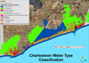
5 – Straight line extensions of the outsides of each of the two jetties at the breachway entrance to Quonochontaug Pond.
6 – A straight line along the west side of East Beach Road.
7 – A straight line along the Ninigret Pond shoreline across the entrance to Foster Cove.
8 – Straight line extensions of the outsides of each of the two jetties at the breachway entrance to Ninigret Pond.
Ninigret Pond – Straight line from westernmost point of Ninigret Wildlife Refuge to westernmost point of Ninigret Conservation Area (from point at approximately 100,489N/279,600E to 95,367N/275,649E RIspf83). Straight line from eastern edge of Ninigret Wildlife Refuge running south to the northeastern point of Lot 2 of the Charlestown Assessors map #8, located on the barrier spit (from point approximately 102,669N/286029E to 99,342N/287,795E RI spf83). The waters between these lines and bounded by the shoreline of the pond are Type 1. (Adopted by Council January 22, 2008)
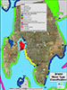
Cranston
59 – A straight line running northwesterly from the easterly side of the Pawtuxet Cove breakwater to the tip of Pawtuxet Neck.
60 – The base of the falls at the Pawtuxet River.
61 – From the southern side of the Port Edgewood breakwater, thence easterly to the dolphin on the east side of dredged access channel to Fields Point, then southeast to the southern boundary of the Mobil Oil Company property in East Providence.
Type 4 Waters – A line starting from the southern end of the Port Edgewood breakwater easterly and 500 feet offshore to include the cove immediately east of the Save the Bay center. (Adopted by the Council on September 25, 2007)
East Greenwich
49 – A straight line running due east from the south side of the East Greenwich Town Dock property across Greenwich Cove to where it intersects with land at Goddard State Park.
50 – A straight line from the tip of Long Point at Goddard Park westerly to the opposite shoreline and intersecting the most northeasterly corner boundary of the Marina Perimeter Limit of Norton’s Marina authorized under CRMC Assent 2002-05-005. The corner boundary coordinate is 212,929N/343,158E RIspf83. (Adopted by the Council on April 7. 2009)
East Providence
61 – A straight line running generally westerly from the southern end of the Mobil Oil Company property to the dolphin on the east side of the dredged access channel to Fields Point, thence to the south side of the Port Edgewood breakwater in Providence.
65 – A straight line running WNW from the Union Oil property boundary with Bold Point Park in East Providence to the easterly boundary of the State of Rhode Island property (parcel 18-344) at India Point. (Adopted by the Council on January 27, 2010)
Type 5 Waters, Bold Point – Tidal waters bounded by line 65 to the north then to 265, 719N/357,428E RIspf83 to 265,789N/357,602E RIspf83, thence running along the shoreline and out to a distance of 100 feet offshore. (Adopted by the Council on January 27, 2010)
66 – The western edge of the former railroad causeway.
67 – The western edge of the former railroad causeway.
68 – The western edge of the former railroad causeway.
69 – The northern side of the culverts and breachways under Crescent View Avenue.
70 – A straight line along the southern bulkhead wall of Lavin's Marina, then straight across the channel to where it meets the spit on the western shore.
140 – A straight line starting approximately 120 feet south of the existing Providence & Worcester quay (parcel 7-1-3) running WSW and more or less perpendicular to the federal channel out into the river ending approximately 120 from the federal channel. (Adopted by the Council on January 27, 2010)
141 – A straight line starting at the boundary of parcels 109-1-1 and 109-1-3 running WSW and more or less perpendicular to the federal channel out into the river ending approximately 120 from the federal channel. (Adopted by the Council on January 27, 2010)
142 – A straight line starting at the boundary of parcels 210-3-6 and 210-3-8 running West out into the river stopping approximately 120 from the federal channel. (Adopted by the Council on January 27, 2010)
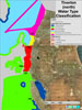
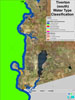
Jamestown
122 – A straight line from shore along the southern side of the docking area at Fort Cove.
123 – A line bordering the southern side of the Newport Bridge.
124 – A straight line extension from the southern side of Weeden Lane.
125 – A straight line from the southern end of Maple Avenue to the end of the large wharf at Beaverhead.
126 – A straight line from Southwest Point to the tip of Shore Point.
Straight line extending seaward perpendicular to the shore at the southern-most boundary of Jamestown Estates Conservation Area (from point at approximately 156,752N, 358,389E RIspf83 to a point at approximately 156,753N/357,601E RIspf83), and a straight line extending perpendicular to the shore at the northernmost boundary of Watson Farm (from approximately 153,357N/361,079E to 153,349N/360,266E RIspf83). The waters within the polygon formed by these lines and bounded by the Jamestown shoreline to the east and the Type 4 waters boundary to the west are Type 1. (Approved by the Council January 22, 2008)
Little Compton
131 – A straight line across the entrance to the Sakonnet River from the tip of Sachuest Point to the southern tip of West Island near Sakonnet Point.
Sakonnet Harbor
132 – The water area immediately adjacent to the barrier beach, starting at Point A (the northeast edge of Lot 385 where the eastern boundary of the barrier beach, identified by Dr. Boothroyd, intersects with the shore) then extending toward the western shore boundary of the barrier beach designated by Dr. Boothroyd to Point B (where a line drawn in a northerly direction as an extension of the eastern boundary of Lot 429 forms an intersect) are designated as Type 2. The remainder of the water area in Sakonnet Harbor are designated Type 5.
Middletown
110 – The northern border of the rubble-mound breakwater.
111 – A line extending out to meet the tip of the rubble-mound breakwater from the northernmost tip of Coddington Point.
131 – A straight line across the entrance to the Sakonnet River from the tip of Sachuest Point to the southern tip of West Island near Sakonnet Point.
Narragansett
9 – A straight line running from the most western tip of Little Comfort Island to the most eastern tip of High Point.
14 – A line running southerly from the southern end of the eastern jetty of the Point Judith Pond breachway and following the eastern side of the navigation channel, as designated by the U.S. Army Corps of Engineers, to the East Gap of the Harbor of Refuge. See Salt Ponds Region SAMP 930.1.B.3.
15 – A line running generally southerly along the seaward side of the jetties and breakwater of the Harbor of Refuge. See Salt Ponds Region SAMP 930.1.B.3.
16 – A line running generally northerly and then westerly 200 feet into the pond and parallel to the Galilee bulkhead to the southwestern end of the Great Island Bridge. See Salt Ponds Region SAMP 930.1.B.3.
17 – A line running generally northerly along the Jerusalem shoreline 200 feet into the pond and parallel to state-owned property. See Salt Ponds Region SAMP 930.1.B.3.
18 – A line along the eastern side of the bridge between Galilee and Great Island.
20 – A straight line running from west to east through the center of Nun buoy #24.
21 – A straight line across the inlet to Long Cove at its most narrow point.
22 – A straight line across the inlet to Champlin Cove from the tip of Cedar Point to the southernmost point on Harbor Island.
23 – A straight line across the entrance to the Narrow River from the south side of Clump Rocks to the tip of the Narragansett Beach barrier spit.
24 – A straight line across the entrance to Pettaquamscutt Cove from the northernmost tip of land at Little Neck West of the Sprague Bridge, thence generally northwesterly, touching the northeastern border of the wetland called "sedge beds", thence continuing straight to where it meets land on the northern part of the cove entrance.
25 – A straight line extension of the south side of Bonnet Shores Road.
Newport
111 – A line extending out to meet the tip of the rubble-mound breakwater from the northernmost tip of Coddington Point.
112 – A line bordering the southernmost side of the northern bridge connecting Coaster's Harbor Island to Aquidneck Island.
113 – A line bordering the northern side of the bridge on Training Station Road which connects Coaster's Harbor Island to Aquidneck Island.
114 – A straight line extending from the southern tip of Coaster's Harbor Island to a point where it meets with a straight line extension of an unnamed road.
115 – A line along the southern side of the Newport Bridge
116 – A line along the northern side of the causeway to Goat Island
117 – A straight line commencing in the southeast corner of Newport Harbor, running generally northwesterly through the so-called "Spindle marker," to the point where it meets the edge of the federally established and maintained anchorage area, then generally northerly along the eastern side of the anchorage area, thence westerly to the southern boundary of the Port of Call Marina on Goat Island.
118 – A line along the western side of the breakwater near Ida Lewis Rock.
119 – A straight line extension from shore along the western side of the pier.
120 – A straight line extension from shore along the southern side of the state-owned boat launching ramp.
121 – A straight line extension from the northeastern tip of the Fort Adams anchorage basin easterly to the southern light on Goat Island.
North Kingstown
26 – A straight line extension of the southern border of the open-space zone on the east side of the Pettaquamscutt River.
27 – A straight line extension of the boundary between the RL and RH zones.
28 – A straight line along the north side of Waldron Avenue.
29 – A straight line across the entrance to Duck Cove at its narrowest point from the northern side of the small peninsula, running generally southeasterly to where it meets the opposite shore on Little Tree Point.
30 – A straight line across the southwestern side of the old railroad causeway.
31 – A line along the south side of Hussey Bridge.
32 – A line along the western side of the bridge on Brown Street.
33 – A straight line across the entrance to Wickford Cove from the tip of Big Rock Point to the tip of the northern peninsula at the end of West Main Street.
34 – A line along the western side of the breakwater from Sauga Point, running across the entrance channel to Wickford Harbor and along the western side of the breakwater from Poplar Point.
35 – A straight line from the base of the breakwater at Sauga Point to the eastern tip of Cornelius Island.
36 – A straight line extension of Pleasant Street
37 – A straight line extension of the northeast side of Enfield Avenue.
38 – A straight line from the southern tip of Rabbit Island to the western side of the launching ramp at Long Point.
39 – A straight line from the northeast side of Rabbit Island to the tip of Calf Neck.
40 – A straight line extension from the end of the fence separating former Navy lands from private lands, extending offshore 2,000 feet, then turning generally easterly and running to a point where it meets the southern side of the Navy channel.
41 – A line along the east bulkhead wall in the small embayment on the south side of the Allen Harbor entrance channel to where it meets the opposite shore.
42 – A straight line from the northern boundary of Navy property.
43 – A straight line from the northern end of Narragansett Street.
44 – A straight line from the southeast tip of Marsh Point to the tip of Pojac Point.
Bissel Cove – Straight line extension perpendicular to shore at northernmost boundary of Bissel Cove DEM property (from point at approximately 170,087N/347,011E to 170,261N/347,659E RIspf83). Straight line extending from northernmost boundary on western side of Bissel Cove DEM property southwesterly to a shoreline point at the end of Shady Cove Road (from point at approximately 170,085N/346,999E to 168,678N/346,603E RIspf83). The area east of these lines and bounded by the shoreline and line 27 are Type 1 waters. (Adopted by the Council January 22, 2008)
Pawtucket
64 – The base of the falls at Main Street in the City of Pawtucket.
Portsmouth
96 – A straight line from the tip of Gull Point running generally south-southwesterly, to the boundary between state and private lands on Prudence Neck. (The water use classification boundary around the north end of Prudence Island and Patience Island follows the 18-foot bathymetric contour line. This is consistent with the boundary of the area protected by provisions of the federal Estuarine Sanctuary Program.)
97 – A line perpendicular to the shore from the southern side of the rocky extension north of Prudence Park.
98 – A line from the outlet of a small, westerly flowing stream south of Prudence Park and north of Crow's Swamp.
99 – A straight line extension of the boundary between public state park lands and privately owned lands.
100 – The outlet of Mill Creek.
101 – A line extending northerly from the northern tip of Hog Island.
102 – A straight line extending easterly from a point 50 feet north of the edge of the adjacent marsh.
103 – A straight line extending northerly from the boundary of Lots 8 and 9, Town Map 17.
104 – A line connecting the westernmost points of land bordering the entrance into the Bend Boat Basin.
105 – A line connecting to the southernmost border of line 104 and extending westerly 50 feet from shore; thence generally southerly, maintaining a 50-foot distance from shore and the outer perimeter of the wharves and piers of the Melville industrial facility; thence easterly to connect land at a point 50 feet south of the southernmost pier.
106 – A straight line extension of Robin Road.
107 – A straight line connecting the north sides of the abutments of the former Old Stone Bridge.
108 – A straight line along the west side of the bridge connecting Point Road and Hummock Avenue at the entrance to Blue Bill Cove.
109 – A straight line from the southern border of the industrially zoned area in Tiverton to the tip of the peninsula on the north side of Brewer's Marina in Portsmouth.
Providence
62 – Upstream side of the Fox Point Hurricane Barrier.
63 – The western side of the Park Street bridge over the Woonasquatucket River.
65 – A straight line running WNW from the Union Oil property boundary with Bold Point Park in East Providence to the easterly boundary of the State of Rhode Island property (parcel 18-344) at India Point (Adopted by the Council on January 27, 2010).
Type 5 waters bounded between lines 62 and 63. Type 4 waters west (upstream) of Park Street bridge.
Type 1 Waters – Along the Providence shoreline of the Seekonk River from a point starting 250 feet north of the Narragansett Boat Club property (parcel 41-258) north to the Pawtucket city line and out to within approximately 50 feet of the existing federal channel. (Adopted by the Council on January 27, 2010)
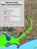
South Kingstown
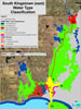
9 – A straight line running from the most western tip of Little Comfort Island to the most eastern tip of High Point.
10 – A straight line across Smelt Brook Cove from the eastern tip of Buttonwoods Point to the eastern tip of Crown Point.
11 – A line across Congdon Cove from the southern tip of the peninsula on the west side of Billington Cove to the southeastern tip of Cummock Island; thence turning due westerly until it touches the mainland on the south side of Congdon Cove.
12 – A straight line running generally westerly from the border between the RL80 and open-space zones on Gooseberry Island to the border between the open-space and commercial zones south of the Kenport Marina.
13 – A straight line running from a southern tip of land now or formerly of Collins/Bassett/Murray to the most easterly side of a small salt marsh on land now or formerly of Woodcock/ Roberton/McCall.
17 – A line running generally northerly along the Jerusalem shoreline 200 feet into the pond and parallel to state-owned property. See Salt Ponds Region SAMP 930.1.B.3.
19 – A line across the northernmost side of the Route 1 bridge.
20 – A straight line running from west to east through the center of Nun buoy #24.
23 – A straight line across the entrance to the Narrow River from the south side of Clump Rocks to the tip of the Narragansett Beach barrier spit.
24 – A straight line across the entrance to Pettaquamscutt Cove from the northernmost tip of land at Little Neck West of the Sprague Bridge, thence generally northwesterly, touching the northeastern border of the wetland called "sedge beds", thence continuing straight to where it meets land on the northern part of the cove entrance.
Tiverton
107 – A straight line connecting the north sides of the abutments of the former Old Stone Bridge.
109 – A straight line from the southern border of the industrially zoned area in Tiverton to the tip of the peninsula on the north side of Brewer's Marina in Portsmouth.
127 – A straight line extension of the northern boundary of land now or formally known as Charter Oil to its intersection with the existing Type 4 Water Designation.
128 – A straight line along the south side of the Nannaquaket Pond Bridge.
129 – A straight line extension of the south side of Island View Road.
130 – A straight line at the north side of the Nonquit Pond Dam.
Warren
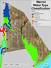
81 – Along the southern side of the old railway causeway.
82 – A straight line from the north side of the end of Stanley Avenue running due easterly to a point of land on the opposite shore.
83 – Along the pipeline crossing of Belcher Cove.
84 – A straight line extension of the south side of Company Street.
85 – At the southern end of the industrially zoned area.
86 – At the outlet of a small stream south of Locust Street.
95 – A straight line from the tip of the peninsula at end of Narrows Road in Bristol to the tip of the peninsula near the end of Brownell Street in Warren.
Warwick
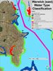
44 – A straight line from the southeast tip of Marsh Point to the tip of Pojac Point.
45 – A straight line from the end of Bradford Avenue.
46 – A straight line across the creek entrance south of Sandy Point.
47 – A straight line along the western side of Beachwood Drive.
48 – A straight line extending northerly from the eastern border of Goddard State Park.
49 – A straight line running due east from the south side of the East Greenwich Town Dock property across Greenwich Cove to where it intersects with land at Goddard State Park.
50 – A straight line from the tip of Long Point at Goddard Park westerly to the opposite shoreline and intersecting the most northeasterly corner boundary of the Marina Perimeter Limit of Norton’s Marina authorized under CRMC Assent 2002-05-005. The corner boundary coordinate is 212,929N/343,158E RIspf83. (Adopted by the Council on April 7. 2009)
51 – A straight line from the tip of Cedar Tree Point to the south side of the breakwater at Folly's Landing.
52 – A straight line from the base of the westernmost groin at Oakland Beach to the base of the easternmost groin on Buttonwood Point.
53 – A straight line from the northern side of the end of Randall Street to the base of the easternmost groin at Oakland Beach.
54 – A straight line extension of Lippitt Avenue.
55 – A straight line extension of Talcott Street.
56 – A straight line running from a point of land on the south side of Occupasstuxet Cove to the tip of the peninsula on the east side of the cove.
57 – A straight line extension from the south side of a launching ramp facility on the northern side of Passeonquis Cove.
58 – The northern side of the rubble-mound connector running easterly from the northeast tip of Salter Grove to the Pawtuxet Cove breakwater.
59 – A straight line running northwesterly from the easterly side of the Pawtuxet Cove breakwater to the tip of Pawtuxet Neck.
60 – The base of the falls at the Pawtuxet River.
Within Line 53 (Warwick Cove) – adopted by the Council on October 26, 2004
Type 2 Waters
Type 1 Waters
Type 2 Waters
Type 5 Waters
Baker’s Creek
Type 1 Waters – Tidal waters bounded by Lot 201 in Plat 367 and Lots 114 and 116 in Plat 368 to a distance of 500 feet off shore. (Adopted by the Council on April 7, 2009)
Chepiwanoxet Point and Greenwich Cove
Type 1 Waters – Tidal waters bounded by Lots 11, 29, 83, and 94 in Plat 221 to a distance of 500 feet off shore. (Adopted by the Council on April 7, 2009)
Type 2 Waters – The existing Type 2 waters west of Chepiwanoxet Point shall extend southward until meeting the amended line delineating Type 5 waters. (Adopted by the Council on April 7, 2009)
Type 5 Waters – Tidal waters bounded by line 50 to the north and line 49 to the south along the western shoreline of the cove.
Westerly
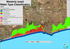
1 – A straight line extension of the northern boundary of Viking Marina.
2 – A straight line extension of the south side of the industrially zoned area.
3 – A straight line across the entrance to Watch Hill Cove from an extension of the western side of Meadow Lane to the tip of the jetty on the north side of Napatree Beach.
4 – Straight line extensions of the outsides of each of the two jetties at the breachway entrance to Winnapaug Pond.
Stedman Government Center
Suite 116, 4808 Tower Hill Road, Wakefield, RI 02879-1900
Voice 401-783-3370 • Fax 401-783-2069 • E-Mail cstaff1@crmc.ri.gov
![]()
![]()
An Official Rhode Island State Website