![]()
![]()
![]()
![]()

RI Coastal Resources Management Council
...to preserve, protect, develop, and restore coastal resources for all Rhode Islanders
![]()
![]()
![]()
![]()
...to preserve, protect, develop, and restore coastal resources for all Rhode Islanders
Two CRMC ROWs Adopted by Angler's Adopt-An-Access Program
July 6, 2005, WAKEFIELD — The RI Saltwater Anglers Association has adopted two RI Coastal Resources Management Council designated right-of-ways through its Adopt-an-Access program, the first two under its initiative, in the towns of Barrington and Middletown. The RISAA and towns have worked in conjunction with the CRMC on the access program, and the Council recently approved signage for both locations, which will also feature the CRMC logo.
The RISAA has adopted the two rights-of-way through its initiative to ensure that they are maintained and protected as scenic access points that lead to quality fishing sites, to be utilized and enjoyed by the public. The right-of-way is now further protected from the rapid development of the coastline, and the lapse of time, which has left many ROWs overgrown and difficult to access. The CRMC is working with the association and Rhode Island municipalities to re-establish these rights-of-way as accessible scenic ways.
The Daunis Right-of-Way, located on Plat 5, Lot 85 in Barrington, is an 8,322 square-foot parcel bordered on the north by a canal, on the east side by Nayatt Road, on the southern side by the former Daunis property and on the West by Narragansett Bay. It is identified by the designation P-1 in the CRMC annual ROW report, Designation of Public Rights-of-Way to the Tidal Areas of the State, July2003-June 2004.
The right-of-way was first recorded in the plat by the town as a relocated paper street in 1931. It was later designated as a public right-of-way by the CRMC in 1981.
According to Council documents, the Daunis ROW was deeded to Cecil D. Sartor, son-in-law of the Daunis’ in 1949. A newspaper article in the Barrington Times in 2003 brought light to a proposal to develop the right-of-way into public parking for seven vehicles. The Sartor family sued the town of Barrington that year in order to prevent the town from developing the parcel, characterizing the right-of-way as a “footpath” that was never open to vehicular traffic. According to CRMC documents, the Sartors maintained that the public only had right to walk to the shore and sought to bar the town from altering the parcel.
The courts subsequently ruled that motor vehicle access and parking was consistent with the original dedication of the street as a right-of-way by Charles D. Owen in 1915, which was opened in exchange for the closing of another street as part of his property. The CRMC granted a permit to the town, with the conditions that the town could improve the ROW for parking, but could not pave it.
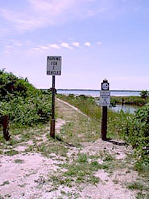
A lack of parking at these CRMC designated sites is recognized as the most common impediment to public rights-of-way.
The Council granted approval for signage for the Daunis ROW on June 22, 2005, through the Adopt-an-Access program. Signage has been installed at the site, identifying it as a public right-of-way.
The Tuckerman Right-of-Way, identified by the CRMC as Y-11 (Plat 122), is located at Tuckerman Avenue opposite Wolcott Avenue in Middletown. It is an approximately 30-foot right-of-way leading 400 feet down to the ocean between lots 138 and 130, with a circular carriage turnaround at the ocean. Platting for this right-of-way, according to CRMC documents, dates back to 1872. Documentation reads:
“Lot conveyed to F. Squires, area 6.331 acres to center 30-foot road, scale 100 feet to one inch. W.M. Dame, Surveyor.” It was recorded as part of a warranty deed from Lucius Tuckerman and others to Frank Squires dated Aug. 5, 1872. The ROW is bordered by Tuckerman Avenue to the north, the Clam Bake Club to the southwest and the ocean to the southeast. The CRMC granted approval for signage on June 2, 2005.
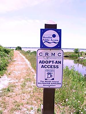
The installation of signage involves excavating 3-4-foot deep holes and setting a post in concrete in each. One post, at the entrance of the ROW, will have a CRMC “Shoreline Public Access” sign and a RI Saltwater Anglers Association “Adopt-an-Access” sign attached to it. Under its Adopt-an-Access program, a RISAA ROW monitor will submit monthly written reports on conditions and activities at the ROW to the association’s public access committee. A second post at the seaward end of the right-of-way, will have the CRMC “Code of Conduct While Using Public Rights-of-Way to the Shore,” multi-lingual signage.
“The CRMC applauds the work of the RI Saltwater Anglers Association, in conjunction with the Council and towns of Barrington and Middletown on the adoption of these two important rights-of-way under the RISAA Adopt-an-Access program,” said Michael M. Tikoian, CRMC chairman. “In addition to their status as CRMC Rights-of-Way, they will now have additional protection from development and will be maintained as access points to prime fishing spots, to be enjoyed by all. We encourage other Rhode Island municipalities to participate by following Barrington and Middletown in this initiative.”
Under Title 46, Chapter 23 of RI General Laws, the CRMC has jurisdiction over the discovery and designation of public rights-of-way.
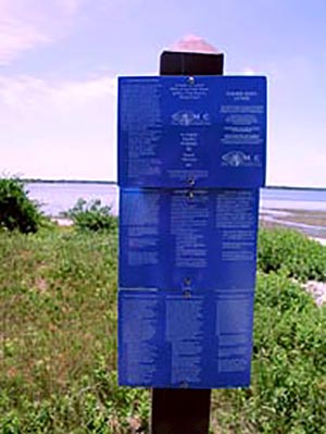
Multi-language signage identifying the Daunis ROW as a CRMC designated right-of-way and as an Adopt-an-Access ROW
Stedman Government Center
Suite 116, 4808 Tower Hill Road, Wakefield, RI 02879-1900
Voice 401-783-3370 • Fax 401-783-2069 • E-Mail cstaff1@crmc.ri.gov
![]()
![]()
An Official Rhode Island State Website