![]()
![]()
![]()
![]()

RI Coastal Resources Management Council
...to preserve, protect, develop, and restore coastal resources for all Rhode Islanders
![]()
![]()
![]()
![]()
...to preserve, protect, develop, and restore coastal resources for all Rhode Islanders
CRMC works with Providence community to improve public access
January 15, 2016 WAKEFIELD – Through its oversight of the Providence Harbor Management Plan, the first for the city, the Rhode Island Coastal Resources Management Council (CRMC) has become an integral player in public access improvements in a number of different areas in Providence.
The CRMC worked with the City of Providence to create their HMP – a major component of which was promoting public access – by working with the city and the other partners to add more instances and a better variety of public access. CRMC staff also worked with the Providence harbormaster and the Providence Harbor Commission to identify potential mooring fields to be adopted under the plan. From eight potential locations, one was identified as appropriate for a mooring field that accommodates 10 moorings. Three others were identified for a total of 12 moorings for transient anchorage – two in Old Harbor, five at the eastern end of India Point Park, and five in the Seekonk River adjacent to the Gano Street Park boat launch ramp.
The 12 transient moorings are being offered through the revival of a US Fish and Wildlife Service program designed to encourage transient boaters to explore Rhode Island harbors. The RI Department of Environmental Management is the state agency that will administer the funding and program. Through its involvement in the Providence HMP process, the CRMC coordinated with DEM to include the transient anchorage program in the Providence HMP, making the Council instrumental in identifying the three locations for those transient moorings.
“The CRMC was an active partner in working with the Providence Harbor Commission to bring the City’s first ever HMP to the City Council for adoption, which is hoped for during the January 21, 2016 City Council meeting. We were pleased to be an integral part of the process,” said Kevin Cute, the CRMC’s marine resources specialist. “Through traditional means – the harbor management planning process – we assisted the City toward identifying new public access opportunities, and we also forged new partnerships to that end.”
Through one of these partnerships, the CRMC provided technical assistance to the Seekonk Riverbank Revitalization Alliance (which includes members of the Blackstone Park Conservancy and Narragansett Boat Club) regarding improvements to Blackstone Park where it occurs along the Seekonk River in Providence.
Proposed changes to the waterfront along a section of River Road in Providence include a modified two-way traffic flow, a multi-use path, increased recreational fishing and kayaking opportunities, as well as additional rights-of-way with associated parking. Significant upgrades to the storm water management infrastructure have also been proposed, with the CRMC continuing its role for the execution of the project.
According to Rick Richards, a member of the Alliance, the impetus for the River Road project was the shut-down of the road a few years ago for work on York Pond. The community noticed the positive change in the area, and sought to make it permanent.
“Without vehicular traffic, pedestrians, bicyclists, bird watchers and others were able to use the area recreationally without fear of being run over,” he said. “This work was done in the winter and, in the following spring, a group of interested people spontaneously got together to see whether the road could be shut down on a more permanent basis. Although the original goal of shutting down the road to vehicular traffic has evolved, that was the beginning of the work and, amazingly, the original group has stuck with the project since then.”
The project has a number of goals: to restore the ecological health of the shoreline and make it a better filter for stormwater runoff, while making it more aesthetically pleasing; create access to the river via one or two points to launch kayaks or other small vessels, access for recreational fishing and possibly a viewing platform for nature enthusiasts; install a multi-use path along the shoreline, creating a link north from Richmond Square along the Seekonk River and connecting the path to Blackstone Boulevard; calming traffic and creating parking by narrowing the road and creating a safer two-way traffic flow; and creating a shoreline park system.
“When these projects are completed, they will create a green zone accessible to people that extends from Fox Point all the way to the northern tip of Gulf Avenue,” Richards said. “This would be a tremendous recreational asset for the people of Providence and our state.”
The CRMC also served as an advisor to City Walk, a public-private collaboration led by the Providence Plan and the Jewelry District Association. City Walk’s goal is to establish a network of pedestrian-bicycle pathways that link core neighborhoods in Providence to India Point Park, the city’s premiere coastal waterfront park. The CRMC conducted research on shoreline public access, specifically the existence of the Harbor View Trail, a former initiative that was never implemented, designed to create a walkway similar to Boston’s Freedom Trail with points of information posted along the route. The trail is between the Roger Williams monument on Gano Street and the Crawford Street bridge, and connects the Providence and Seekonk Rivers. The CRMC discovered plans exist, should City Walk decide to implement the walkway.
Finally, the CRMC can trace its significant contributions to improved public access to the shore in Providence to its discovery of the East Transit Street Right-of-Way, which led to a partnership creating the existing Gano Street boat ramp, the second in the city. CRMC staff discovered the adjacent auto repair shop was using city property to store automobiles; after notifying the city, the CRMC and the Providence Parks Department developed plans for the launch facility that exists today. The CRMC was the driver of this initiative from start to finish – the Council notified DEM of the funding opportunity under the Federal Aid and Sportfish Restoration Act to construct the facility – and pursued to matter for several years until the facility’s dedication on July 14, 2014.
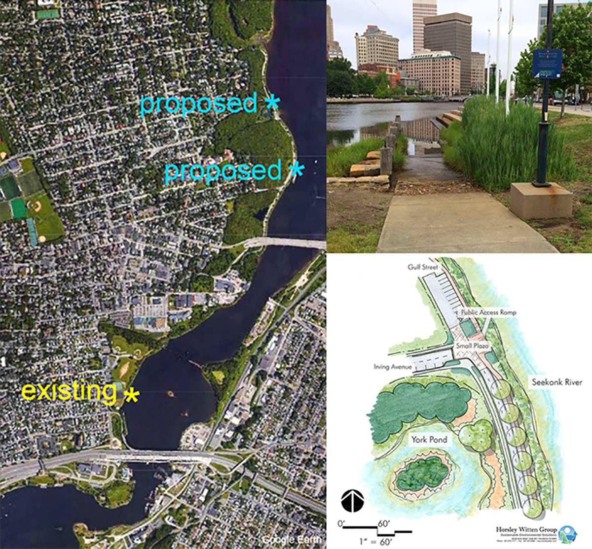
The aerial photo above depicts the location of the existing Gano Street Park boat ramp, as well as the location of the various proposed improvements to the area at the Narragansett Boat Club and farther north, and the Irving Avenue Right-of-Way, which is also shown in the rendering at right. The top photo shows the existing small craft boat ramp (used for kayaks) on the Providence River near the RI School of Design, to which the Irving Street access could be similar. (Graphics courtesy of Rick Richards)
Stedman Government Center
Suite 116, 4808 Tower Hill Road, Wakefield, RI 02879-1900
Voice 401-783-3370 • Fax 401-783-2069 • E-Mail cstaff1@crmc.ri.gov
![]()
![]()
An Official Rhode Island State Website