![]()
![]()
![]()
![]()

RI Coastal Resources Management Council
...to preserve, protect, develop, and restore coastal resources for all Rhode Islanders
![]()
![]()
![]()
![]()
...to preserve, protect, develop, and restore coastal resources for all Rhode Islanders
CRMC, URI introduce new risk index tool under Beach SAMP
February 4, WAKEFIELD – The Rhode Island Coastal Resources Management Council (CRMC), along with the University of Rhode Island’s Coastal Resources Center and RI Sea Grant, last night unveiled its latest Shoreline Change Special Area Management Plan (Beach SAMP) tool: the Coastal Environmental Risk Index, or CERI.
The index, created for the Beach SAMP by its research team, is the first ever in Rhode Island that will provide an objective, quantitative assessment of risk to both structures and infrastructure from storm surge and waves in the presence of changing climate conditions, in particular, sea level rise.
Rhode Island planners and managers will have another tool in their arsenal – in addition to the recently-introduced mapping tool, STORMTOOLS – to utilize in making decisions based on storm events to anticipate risk to infrastructure, property, and emergency services along the coast. CERI uses the STORMTOOLS surge and wave maps, and the Beach SAMP shoreline change maps as a foundation, as well as data from the US Army Corps of Engineers, North Atlantic Comprehensive Coastal Study (using recent data from Superstorm Sandy).
The index – an online GIS-based tool – assesses the risk to structures and infrastructure in the event of storm surges, including flooding and waves, taking into account sea level rise and shoreline erosion and/or accretion. It calculates percent damage for structures and infrastructure associated with storm flooding, as well as inundation, waves and erosion, and combines all of these factors for a total assessment.
As a test for the performance of CERI, the index has been applied to the eastern end of Matunuck Beach, which has one of the highest erosion rates in the state. According to the University of Rhode Island, the area is characterized by high density, single-story homes, a few elevated residences (using pilings), and several coastal businesses – a typical mixture of structures for the southern coast of the state. The main road in and out of this area, Matunuck Beach Road, is being threatened by erosion. Spaulding and researchers at URI applied CERI to this area to determine the damage to individual structures for the 100-year return period storm surge (the likeliness of a storm of this magnitude is once every 100 years, by definition), with and without sea level rise. The index shows that the damage to the single-story homes in flooded areas is extensive, with elevated structures sustaining significantly less damage. Wave damage is rampant in areas close to the shoreline, where storm wave heights are large, while inland areas sustain most damage from inundation.
The Beach SAMP team plans to apply CERI to Narragansett Bay in Warwick, and the southern coastline in Charlestown in a HUD-funded pilot study, with plans to extend the pilot to all of Washington County if and when funds become available.
“We are excited that Warwick was selected to be part of the CERI pilot study,” said Mayor Scott Avedisian in a statement. “With 39 miles of coastline in the City, we can never have too much information when it comes to sea levels rising and how it may affect our infrastructure in the coming years. With CERI’s metrics, we’ll have a better understanding of the potential impact sea level differences will have in our community, thus giving us the tools to make more educated decisions moving forward.”
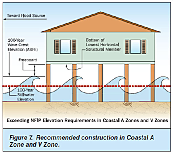
FEMA schematic of residential structure on pilings in the presence of storm inundation and waves (credit: URI)
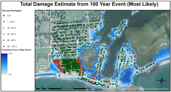
Most likely percent damage (%) by structure (dots) for the eastern end of Matunuck Beach, RI; 100 yr return period flooding. The flood inundated areas are shown in blue, the darker the blue the greater the inundation depth. (Credit: URI)
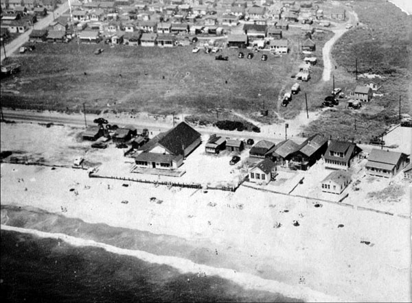
Eastern end of Matunuck Beach, Circa 1950s. (Credit: URI)
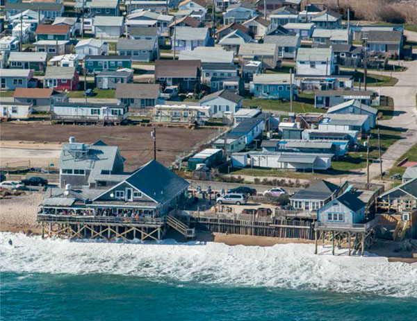
Eastern end of Matunuck Beach, RI, 2010. (Credit: URI)
Stedman Government Center
Suite 116, 4808 Tower Hill Road, Wakefield, RI 02879-1900
Voice 401-783-3370 • Fax 401-783-2069 • E-Mail cstaff1@crmc.ri.gov
![]()
![]()
An Official Rhode Island State Website