![]()
![]()
![]()
![]()

RI Coastal Resources Management Council
...to preserve, protect, develop, and restore coastal resources for all Rhode Islanders
![]()
![]()
![]()
![]()
...to preserve, protect, develop, and restore coastal resources for all Rhode Islanders
Update on the Narrow River Marsh Restoration and Elevation project
October 7, 2016, NARRAGANSETT – Work will be commencing this fall on the marsh restoration within the John H. Chafee National Wildlife Refuge on the Narrow River, and will be visible to residents and users of the river.
There are currently many areas of the marsh where ponded water stays on the surface, even at low tide, drowning vegetation and providing areas for mosquitos to breed. This is thought to be the result of sea level rise, which is happening at an increasingly faster rate due to climate change. Marshes with healthy vegetation are better able to accumulate sediments and build elevation to keep up with rising sea levels. However, recent evidence suggests that most of the marshes in Rhode Island are not keeping pace with sea level rise and drowning.
If the marsh disappears, the important “ecological services” it provides are also lost. Among many other functions, marshes are important habitat for fish and wildlife. To combat drowning, and to hopefully increase the lifespan and resilience of the marsh to future sea level rise and other stressors, the CRMC and its partners aims to restore and elevate the marsh surface.
One method of restoration involves placing dredged material on the surface of the marsh to raise the elevation so that plants can thrive. This method, often called thin layer deposition, will be used in the Narrow River. Material will be dredged from select locations to create depths where eelgrass—another important habitat—can grow. The dredged materials will then be dispersed on the adjacent marsh surface to slightly increase the marsh’s elevation, primarily in areas where the vegetation has died off or become stressed from prolonged flooding. These areas will be replanted with marsh grasses.
Toward the end of October, from Narrow River Kayaks south to Sedge Island, crews will be dredging and depositing the dredged material onto different areas of the marsh. The dredge footprint will create an approximately 65-foot wide channel in the river. Sand from the dredging will be used to help elevate the marshes on the eastern side of the river.
The project will feature a new low-flow method of dredging that will protect the existing marsh plants. Marine dredging is only permitted in the fall and winter months to avoid impacts to fish species such as flounder. The work in the Narrow River will start at the beginning of this window to take advantage of warmer temperatures.
“This is being done in more seasonable weather, earlier in the dredge season, so that freezing of the dredge piles and dredge equipment is limited.” said Danni Goulet, CRMC’s marine infrastructure coordinator. “We also want to make sure it’s done early enough so we can plant the restored areas in the spring.”
How it will look
The dredge equipment will be mounted on barges in the river. Discharge pipes will extend from the dredge onto the marsh to the east, and construction equipment will be on the marsh to spread and grade the sand that is pumped from the river. The work is likely to proceed from north to south, starting just south of Middle Bridge and ending at Sedge Island, just before Sprague Bridge. The work will be audible to those in the area and during the project, access through this stretch of Narrow River will require mariners to exercise caution and listen to the direction of dredge crews for safe passage.
The CRMC encourages caution during the fall months in this stretch of the river, and smart, safe use. “Take the opportunity to head north,” and explore the other beautiful parts of Narrow River, Goulet said.
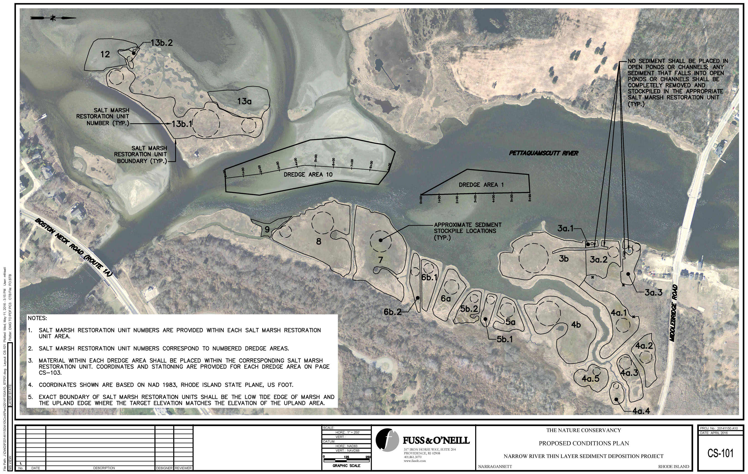
Above, an aerial map shows the areas to be dredged, as well as the collection of different areas of the marsh where the material will be spread to improve elevation in areas where the marsh has degraded. Click for full size.
Other ongoing projects
The Narrow River project is one in a series of Rhode Island projects that will investigate new methods of marsh restoration and enhancement. Last winter, the USFWS conducted a similar restoration and elevation enhancement project at Sachuest Point National Wildlife Refuge with funds from the US Department of the Interior. There, sand from upland sources and offsite dredge projects was brought in by trucks, spread by machinery over the marsh surface and planted with marsh plant species. So far, the results of that project are promising.
In addition to the Narrow River project, marsh restoration work will also begin this fall on Ninigret Pond, as part of the Salt Ponds restoration project funded through DOI and the National Fish and Wildlife Foundation. In 2014, the CRMC received an award of $3.25 million to conduct coastal wetland restoration and planning within the Salt Ponds Region in southern Rhode Island. In December, dredging will begin within the channel of the Charlestown Breachway and nearby areas of Ninigret Pond. The dredged sand will be used for marsh restoration and beach nourishment.
“As sea levels rise, we know if we do nothing, we will lose the vast majority of our salt marshes along with the functions and values that they provide,” said Caitlin Chaffee, policy analyst at CRMC. “We hope that through implementing and monitoring these projects, we can learn about ways that we might buy some of our most valuable marshes more time.”
Stedman Government Center
Suite 116, 4808 Tower Hill Road, Wakefield, RI 02879-1900
Voice 401-783-3370 • Fax 401-783-2069 • E-Mail cstaff1@crmc.ri.gov
![]()
![]()
An Official Rhode Island State Website