![]()
![]()
![]()
![]()

RI Coastal Resources Management Council
...to preserve, protect, develop, and restore coastal resources for all Rhode Islanders
![]()
![]()
![]()
![]()
...to preserve, protect, develop, and restore coastal resources for all Rhode Islanders
CRMC: 2016 in review
The year 2016 marked the 45th anniversary for the R.I. Coastal Resources Management Council, and was one filled with accomplishments and progress. The Block Island Wind Farm started spinning and aquaculture garnered a lot of positive public interest, despite the continued objections to permitting leases. Progress continued on the Shoreline Change (Beach) Special Area Management Plan, including the introduction of additional mapping tools. And two major habitat restoration projects neared completion. Here are some highlights from our year.
Block Island Wind Farm spins
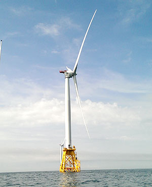
A view of the Block Island Wind Farm, which the CRMC permitted through its Ocean SAMP document
This year, the CRMC and State of Rhode Island saw the completion and start of commercial operation for the nation’s first offshore wind farm. Throughout the year, the CRMC Council continued to be apprised of the project’s progress by the independent Certified Verification Agent (CVA), and in November, Deepwater Wind was granted CRMC Council approval for the commercial operation of the 30MV wind farm – its final approval needed from the coastal management agency. This marked another first for Rhode Island, and the nation, and on December 12, 2016, the turbines began delivering electricity to the region’s grid on a regular basis. The wind farm would not have been possible without the specialized, streamlined permitting process developed by the CRMC as part of its groundbreaking R.I. Ocean Special Area Management Plan (Ocean SAMP), on which the regional Northeast Regional Ocean Plan has been modeled. Through Executive Director Grover Fugate’s work as the state lead for the Northeast Regional Planning Body, the CRMC had extensive input and involvement in the development of the Ocean Plan, which was certified by the National Ocean Council in December 2016.
Beach SAMP work continues
In furthering the work of the CRMC Shoreline Change Special Area Management Plan (Beach SAMP), a comprehensive effort to address sea level rise, coastal shoreline erosion and coastal storm surge flood inundation, new tools and products to assist the state, municipalities and coastal property owners are being developed to address impacts from climate change. The Beach SAMP is intended to provide the best available tools and information to assess risk and vulnerability of coastal property and public infrastructure, and to develop resilient adaptation strategies to reduce the impacts from climate change. The Beach SAMP website has lots of information and links to tools and products. See: www.beachsamp.org.
In early 2016, the CRMC in collaboration with URI Ocean Engineering, URI Environmental Data Center, URI Coastal Resources Center and RISG, introduced the latest tool, the Coastal Environmental Risk Index, or CERI. The CERI tool was created for the Beach SAMP by its research team and is the first ever in Rhode Island that will provide an objective, quantitative assessment of risk to both structures and infrastructure from storm surge and waves in the presence of changing climate conditions, in particular, sea level rise and coastal erosion. This tool will soon be integrated into the STORMTOOLS platform for the communities of Charlestown and Warwick. (CRMC and project partners are being funded in 2017 to extend CERI modeling into Barrington, Warren and Bristol.) CRMC staff utilized STORMTOOLS in review of the Town of Narragansett’s application for a flood-proofing barrier to protect the Scarborough Wastewater Treatment Facility in 2016 and advised the town on the design life of the barrier in relation to increased future risk from storms, flooding, erosion, and sea level rise.
The CRMC updated its Shoreline Change Maps (available here) for all of Washington County in 2016 (with the exception of Block Island, which is coming soon), and also worked on the development of projected shoreline change maps for accelerated erosion from Watch Hill to Point Judith. This work, all done under the auspices of the Beach SAMP, was accomplished by SAMP team member and geologist Bryan Oakley of Eastern Connecticut State University. The accelerated erosion maps will be introduced in 2017.
Coastal Habitats
In 2016, the CRMC continued its leadership role in the preservation, restoration and monitoring of important coastal habitats. With federal funding from the Department of the Interior and National Fish and Wildlife Foundation, the agency led a large-scale salt marsh restoration project in Ninigret Pond. The project involved dredging within the pond’s breachway channel and using the dredged material to enhance the elevation of the adjacent marsh—a restoration technique that is relatively new in New England. The CRMC collaborated with state and federal agencies, the towns of Charlestown and Westerly and non-governmental organizations such as Save The Bay throughout the design and permitting phases of the project. The project is in its final stages and will be completed this spring. Learn more about the project here. The CRMC also consulted on another salt marsh restoration project led by the US Fish and Wildlife Service in the John H. Chafee National Wildlife Refuge. This is a similar project that includes dredging and marsh enhancement, and will also be completed this spring.
The CRMC funded an effort led by the URI Environmental Data Center to map eelgrass habitats throughout Narragansett Bay and Rhode Island’s south shore. CRMC contracted with the US Geological Survey to get aerial images (photos taken from a plane) this summer, which were used by the EDC to map eelgrass. The CRMC also assisted in “ground-truthing” the maps in different locations throughout the bay with an underwater video camera. The new maps will be available on the RI Geographic Information System website for download in 2017.
Awards were made from the CRMC’s Coastal and Estuarine Habitat Restoration Trust Fund for habitat restoration projects throughout the state. This year marked the 13th year of the program, which has distributed $3 million in the form of over 100 grants to state agencies, cities, towns, nonprofit and community organizations for habitat restoration.
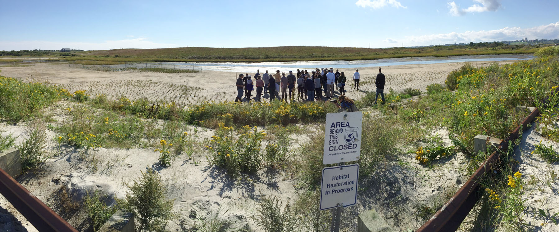
One of the restored and elevated areas within the Ninigret salt marsh in Charlestown, the site of a CRMC habitat restoration and enhancement project in late 2016
CRMC in the community
In early 2016, the CRMC held three workshops Vibrio, for compliance with the state’s regulations for temperature control of harvested shellfish for all aquaculturists. CRMC’s aquaculture coordinator, David Beutel, along with Robert Rheault, executive director of the East Coast Shellfish Growers Association, conducted the mandatory workshops.
In January, CRMC coastal geologist Janet Freedman, and Danni Goulet, marine infrastructure coordinator, met with high school students as part of the Architecture, Construction, and Engineering (ACE) Mentoring Rhode Island program. The students were participating in a national competition and challenge, “Shoreline Design Challenge.” The students chose an area of Rhode Island’s shoreline that presents interesting and diverse challenges, from erosion and flooding, to multiple uses and physical environments. The CRMC staff provided guidance to the students, and showed them a variety of CRMC planning and regulatory tools to assist in their challenge.
Year-long, the CRMC continued its outreach and education work through the MyCoast application and web site (www.MyCoast.org), which encourages the public to take an active role in observing the state of the coast during the year’s extreme high tide events, as well as storm events, by snapping pictures and uploading them to the web site. For each event, the CRMC alerts MyCoast users in advance, and the pictures taken have provided an interesting look into the future. These extreme tide levels provide a glimpse of what the state can expect as sea level rise accelerates with climate change, where water levels could be the daily high tide by mid-century.
To provide the public with a better view of some of the aquaculture operations in Ninigret Pond, the CRMC offered two different tours – three trips in June and three more in September – of a few aquaculture leases in the pond. CRMC’s David Beutel ran the tours and narrated the boat trip out to the farms, and aquaculturists provided information about their operations and methods. The tours were a resounding success, and more are planned for the future.
Beutel also took part in the free summer aquaculture tours, a wading tour of Matunuck Oyster Farm, and a walking tour of the oyster research site in Jamestown. The events were hosted by the University of Rhode Island Graduate School of Oceanography, Coastal Resources Center and Rhode Island Sea Grant, in collaboration with CRMC and Roger Williams University. These tours were also a huge success, filled to capacity.
For more than 30 years, the CRMC has played a major role in the annual Coastweeks celebration, co-hosted by the Council and R.I. Sea Grant, and 2016 was no different. Each year, the CRMC plans events that educate the public on its different endeavors, while celebrating the coast and encouraging Rhode Islanders to get outside. In 2016, the events included an erosion walking tour of Misquamicut State Beach in Westerly, monitoring marine aquatic invasive species at Point Judith Marina, and a tour of Sachuest Point salt marsh in Middletown, the site of a recent marsh restoration and elevation project.
CRMC Executive Director Grover Fugate was particularly active, giving talks on climate change and coastal issues to different audiences, from the White House staff and Rhode Island cities and towns, to banks and the Rhode Island Bar Association. He and Senator Sheldon Whitehouse also started an endeavor to visit the state’s chambers of commerce and speak about the impacts of sea level rise on Rhode Island’s economy and tourism industry.
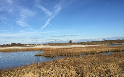
Sachuest Point salt marsh in Middletown, the site of another recent marsh restoration and elevation, and topic of a Coastweeks 2016 walking tour given by the CRMC and USFWS
Public Access
During the summer of 2016, the CRMC announced that RISG had launched a new web-based app that makes getting to Rhode Island’s public access points – including all 222 of the CRMC’s rights-of-way to the shore – easier than ever before. Discovering the Rhode Island Shore (https://www.shoreline-ri.com) was designed to help residents and visitors find their way to pathways, boat ramps, scenic vistas, parks, beaches, wildlife refuges, and fishing sites along Rhode Island’s 400 miles of coastline. The app offers photos of each site, daily tide information based on the Newport tide gauge, real-time local weather conditions, a list of public amenities, and directions to each location that can be synced to the user’s smart device.
After a lull in activity brought on by the deep recession, some new Urban Coastal Greenways (UCG) projects were jumpstarted in 2016. When the UCG policy was adopted by the CRMC in fall of 2006 as part of the Metro Bay Special Area Management Plan (SAMP), the response from businesses and developers in the region was overwhelmingly positive. In 2007, developer Struever Bros. Eccles & Rouse had touted its new 2,000 linear feet of urban public access along the Woonasquatucket River approved by the CRMC as part of a larger redevelopment project, and the UCG policy had approved a total of about 6,100 linear feet of new shoreline access in the SAMP area. The recession brought many of the projects to a halt, but now several new Metro Bay projects are under construction, namely Village on the Waterfront and Kettle Point, both on the East Providence shoreline. When these projects are completed, more than 2.5 miles of new public access (13,450 linear feet) will be available to the public in the Metro Bay urban area.
Program Advancements
In January 2016 the Council approved amendments to the RI Coastal Resources Management Program, Section 145, to update sea level rise (SLR) projections for 2035, 2050 and 2100 using current National Oceanic and Atmospheric Administration (NOAA) models, and based on the Newport, RI NOAA tide gauge. The CRMC’s existing policy in Section 145 is to periodically review the latest scientific data regarding SLR. The amendment gives the State and municipalities proper projections for SLR, which they can then use in consideration of future investments and natural resource restoration efforts. This action also included the formal adoption of the online mapping tool, STORMTOOLS, a comprehensive tool designed to help homeowners and municipalities better understand their risks from coastal storms and flooding, and plan for the realities of sea level rise.
Stedman Government Center
Suite 116, 4808 Tower Hill Road, Wakefield, RI 02879-1900
Voice 401-783-3370 • Fax 401-783-2069 • E-Mail cstaff1@crmc.ri.gov
![]()
![]()
An Official Rhode Island State Website