![]()
![]()
![]()
![]()

RI Coastal Resources Management Council
...to preserve, protect, develop, and restore coastal resources for all Rhode Islanders
![]()
![]()
![]()
![]()
...to preserve, protect, develop, and restore coastal resources for all Rhode Islanders
CRMC works to protect RI’s largest ship graveyard
May 16, 2018, EAST PROVIDENCE – Marine archaeologist and third-generation Rhode Island diver David Robinson is very excited about a collection of old timbers exposed along the East Providence shoreline. He recently discovered that these are the remains of 29 abandoned vessels that make up the largest ship graveyard in Rhode Island – and that’s an amazing feat in a state with a rich shipping and sailing history.
“This site captures the maritime focus that Providence had during its ‘Golden Era,’ at the peak of its history as an industrial port city,” he said one recent morning, the excitement clear in his voice. “The Bay has been a highway forever” and it only made sense that with the birth of America’s Industrial Revolution in Pawtucket, there would be some visible remnants of that time. Among the remains, according to Robinson, are six sailing vessels, a schooner barge, the Bay Queen and Mount Hope sidewheel steamers, and a collection of various types and sizes of scow-barges.
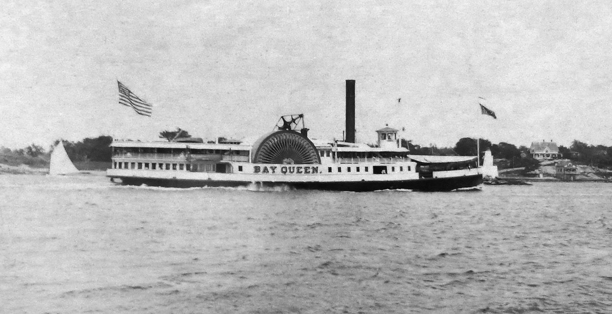
Bay Queen (Photo courtesy of the W. Warren Collection, Providence Public Library Special Collections)
Now, the Rhode Island Coastal Resources Management Council (CRMC) is working with the City of East Providence, the East Providence Historical Society, and East Providence Historic District Commission and others to preserve and bring awareness to the site off Bold Point, called Green Jacket Shoal, and one of the most unique ship graveyards in the country, with Robinson’s help.
“The City has expressed to Chevron that the remnants of the 19th century sailing vessels, barges, steam powered vessels, sidewheel steamboats and floating dry dock are significant historic resources, and that they should be protected and documented,” the city’s HDC Chairman Stephen Greenleaf said in an official response. “The Historic District Commission strongly supports the protection and documentation of this rare historic resource, and we encourage the state agencies, the city council, East Providence Waterfront Commission and private developers to seek a consensus while taking into consideration the preservation of the site, concerns of navigational hazards and the development of the city’s waterfront.”
Through the creation of a Marine Protected Area (MPA) around the submerged vessel and dry dock remains, East Providence’s goal of preserving and increasing awareness of the site will be advanced, and archaeologists like Robinson will be able to continue to study the site’s cultural resources in detail, documenting and preserving the unique information they contain for future generations of Rhode Islanders. The MPA will fall under the auspices of the CRMC’s newest Special Area Management Plan, called the Bay SAMP, which will focus the most up-to-date science on the activities and uses of Narraganset Bay, as well as its natural resources. The city’s historic groups would also like to designate the area as a National Register Historic District for an added layer of consideration and protection.
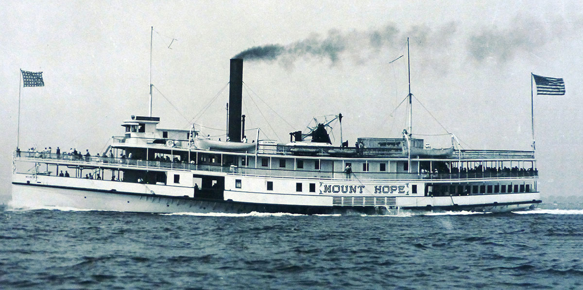
Mount Hope (Photo courtesy of the W. Warren Collection, Providence Public Library Special Collections)
And this site is unlike others in Rhode Island and the rest of the country, Robinson said. Nowhere else can one find the remains of this many vessels in such a small area – approximately 30 acres, of this age – some dating back to the mid-19th century, of this diversity of type – representing six different vessel classes, and this type of construction – all made of wood. And they don’t appear to have been just discarded randomly at Bold Point, which adds to their value, he said.
“These vessels were abandoned at the end of their service lives in two principal areas – close to where a floating dry dock and two marine railways were located and operated by the Providence Dry Dock and Marine Railway Company between 1884 and 1919,” Robinson said. “The submerged remains have contextual integrity. The vessels were being used and maintained here – they were tied to the place – to the ship-building and servicing operations at Bold Point and to the broader industrial maritime cultural landscape of the harbor and the bay at that time.”
Bold Point, or Burges Point as it was formerly known, was one of the first areas of East Providence’s waterfront to be developed and was located in an area called Watchemoket. A number of the people who lived there worked at the shipyard on the Point, and at the coal pier nearby that was built and owned initially by Lehigh & Wilkes-Barre Coal Company. A U.S. Office of Coast Survey 1865 chart of Providence Harbor – the earliest detailed depiction of that waterway Robinson’s research found – refers to the existence of eelgrass on the shoal, the color of which is how the location got its “Green Jacket” name. Robinson cited a printing of “The King’s Pocket-Book of Providence, R.I.” a handy guide to the city, for this bit of history.
The Providence Marine Railway & Drydock Co. at Bold Point was the last Providence shipyard to build wooden merchant sailing vessels, according to Robinson, and it also boasted Rhode Island’s first floating dry dock. It was a shipyard that produced not only three-masted schooners for international trade, but also serviced local vessels, including the Bay Queen and Mount Hope, Robinson said.
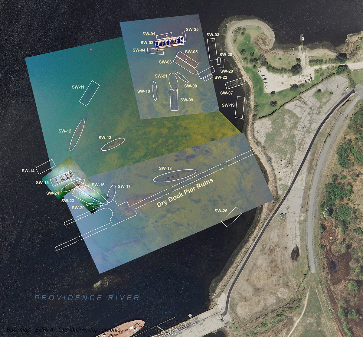
A drone aerial image of the Green Jacket Shoal ship graveyard area with the outlines of the vessel remains overlaid. (Image courtesy of David Robinson, URI)
When Robinson set out to identify the vessels on the shoal, he found the first reference to the graveyard in a Providence Journal article from 1915, lamenting plans to change the course of the Seekonk River (though that never happened because its chief proponent, Charles M. Hays, president of the Grand Trunk Railway, died on the Titanic). An Army Corps of Engineers map from 1931 shows 24 derelict vessels at the site, 17 of which Robinson has determined are still present on the shoal.
Robinson said the graveyard represents “an unusually diverse collection of six classes of wooden merchant vessels that are representative of those that were important in our nation, region, and state’s maritime past. These vessel types include bay and ocean-going side-wheel steamers, smaller harbor steamers, steam-tugs, sailing ships, schooner-barges, and multiple types and sizes of barges (e.g., deck- and hopper-cargo barges, crane-barges, work-barges, etc.), all of which worked in the area and were part of the maritime cultural landscape of the U.S., R.I., Providence, and East Providence.”
Greenleaf said the HDC realizes that while the graveyard is not full of renowned ships (with the exception of the two steamers) and that there are few remaining architectural details (preserved above their former water-lines), the protection and documentation of the vessels, along with interpretive signage, online virtual tours, boat and kayak tours and continued educational outreach has enormous potential to bring awareness of everyday maritime activity of the upper Bay in the late 19th century to the public. According to the commission, it is seeking funding for the signage and has been in contact with the R.I. Historic Preservation and Heritage Commission to determine if the site could be eligible for listing in the National Register of Historic Places.
“Many East Providence residents may not realize that the city’s shorelines were once a thriving industrial waterfront prior to the modern highway system,” Greenleaf said. “While Slater Mill is credited for the birthplace of the industrial revolution, it was places like the East Providence waterfront that had ports, water-based repair facilities and a shoreline rail system that the industries to allow for the transportation of raw materials and finished goods, which was critical for the development of our community and the region. The protection and documentation of Green Jacket Shoal has the tremendous potential for us to learn about our past and offer an insight of the late 19th century social, economic and technological changes.”
Preserve Rhode Island, a statewide historic preservation organization, is also in support of the designation. In a letter to the RIHPHC, Program Manager Susanna Prull wrote, “As an underwater archaeological resource, the Green Jacket Shoal site is virtually unknown to historians and the community and is therefore susceptible to being unappreciated, or even worse, damaged. Listing in the National Register would bring the site the attention it deserves and preserve our important, and sometimes overlooked, maritime heritage.”
Under the CRMC MPA, law enforcement authorities like the R.I. Department of Environmental Management (DEM), the State Police, and the East Providence harbormaster will be authorized by the CRMC to protect the graveyard and the integrity of the remains. It will also establish a restricted perimeter around the entire area.
“Without ships and boats and maritime culture, exploration, technologies, commerce, and defense, the U.S. and R.I. (the ‘Ocean State’) would not exist,” Robinson said. “Another thing that makes the site even more unique is that it is preserved in a place so close to shore and in such shallow water that it is highly visible at low tide and easily accessible to literally millions of people a year. The site presents a truly incredible situation and opportunity.”
“This ship graveyard is unique to Rhode Island and the protection afforded to it by the MPA under the Bay SAMP will preserve it in perpetuity,” said CRMC Chair Jennifer Cervenka. “The CRMC, along with city and state partners and neighbors, must work together to ensure Rhode Islanders will be able to view, access and enjoy this historic resource.”
Stedman Government Center
Suite 116, 4808 Tower Hill Road, Wakefield, RI 02879-1900
Voice 401-783-3370 • Fax 401-783-2069 • E-Mail cstaff1@crmc.ri.gov
![]()
![]()
An Official Rhode Island State Website