![]()
![]()
![]()
![]()

RI Coastal Resources Management Council
...to preserve, protect, develop, and restore coastal resources for all Rhode Islanders
![]()
![]()
![]()
![]()
...to preserve, protect, develop, and restore coastal resources for all Rhode Islanders
In focus: the future of RI’s salt marshes
June 28, 2018, SOUTH KINGSTOWN – Rhode Island is new to the concept of buying salt marshes more time through thin-layer deposition and elevation enhancement, with a completed project at Ninigret and a new one to kick off in Quonochontaug this fall. The R.I. Coastal Resources Management Council (CRMC), the state lead on these efforts, is hopeful that these pilot projects will inform the scientific community about the changing dynamics in our coastal marshes.
“For the design we used the vegetation as a proxy for what our target flooding regime would be,” said Caitlin Chaffee, policy analyst and habitat restoration project manager for the CRMC, of the project at Ninigret. “We took elevation data, vegetation data, coupled those two, looked at plant growth ranges and added some factors to account for compaction, and then there was a sea level rise factor added. Our maximum target elevation was about 6 inches higher than the existing observed mean higher high water elevation. The goal was to create areas built to that elevation in the center that would be gradually sloped down to the existing marsh surface. That way we would get a gradient of different elevations—some would support marsh vegetation now, and some would be areas that would convert to marsh in the near future.”
This topic and others was the focus of a June meeting of the National Oceanic and Atmospheric Administration’s Greater Atlantic Regional Fisheries Office in Rhode Island. The NOAA staff also visited the Ninigret and Quonochontaug marshes with CRMC staff to discuss current and expected salt marsh losses and potential restoration alternatives that might address the rapidly changing conditions in these fragile ecosystems.
In studying marshes along the Atlantic coast, from Maryland, New Jersey, New York and up to Maine, Dr. Neil Ganju of the U.S. Geological Survey at Woods Hole said those areas are accreting well (sediment deposit and decomposition of plants add volume and height to the marsh over time), but that lateral erosion is a cause for concern. Marshes in these areas, he said, are still accreting at a rate equal to or greater than the rate of sea level rise. Rhode Island is not as fortunate, however, and recent studies of accretion rates show that our marshes are generally “sediment starved” and not keeping up with sea level rise.
Ganju studies the movement of sediment on and off salt marshes, from normal and other tidal events and storms, and said the marsh is a continuous vehicle for this movement of material, and that it is cyclical, citing a 1972 study by Alfred C. Redfield. This study, however, did not take into consideration the realities of sea level rise, Ganju said.
“Sediment transport and collection is a zero-sum game,” he said. “You can’t get more sediment.”
There seems to be no pattern of accretion versus sea level rise in marshes in different locations, he said. Some places keep pace with it, some exceed the rate of sea level rise, and other places do not. And in places where marsh loss runs concurrent to sea level rise rates, Ganju said restoration projects’ success depends on a number of factors.
“This depends on the present-day sediment budget of the marsh and the processes leading to deterioration,” he said in a separate interview. “If a marsh is losing sediment from edge erosion and open-water conversion, it may be counter-productive to add sediment to marsh plains that may be lost soon due to these processes. However, a marsh with a relatively neutral sediment budget, with low rates of erosion and open-water conversion, that needs a vertical ‘boost’ may have a longer lifespan and therefore be a better candidate for sediment addition.”
Ganju said it would also make sense to add material in places with open water ponds that are adjacent to upland salt marsh migration routes, which would help in the natural process of creating salt marsh in a transition area, as our salt marshes migrate inland.
The University of Rhode Island’s Dr. Simon Engelhart sees the dynamics of salt marshes through a different lens. As an associate professor of geosciences, Engelhart has studied glacial isostatic adjustment and salt marshes, and told the NOAA group that the subsidence widely seen in salt marshes like those in Rhode Island is a simple function of the land surface settling back down from being uplifted 20,000 years ago by the ice sheets.
The East Coast is experiencing subsidence (sinking of land masses), and this is also true of the coastal salt marshes, which are already being burdened by rising sea levels, erosion and low rates of accretion. The ice sheets present over this part of North America during the last Ice Age pushed down the Earth’s crust and the crust displaced the malleable mantle, Engelhart explained.
“Now that the ice is gone, the displaced mantle is settling back to equilibrium,” he said. “So we have subsidence.” And while the northeast appears to be sinking, in simple terms, Sweden is actually uplifting and at a greater pace than sea level rise.
So how do we distinguish the rate of sea level rise versus land subsidence? There are a number of ways, according to Engelhart. Using geological records from fossil salt marshes formed in the last 2,000 to 4,000 years can tell us past relative sea level. Using GPS receivers continuously monitoring the elevation of the land also provide valuable data. Most states have at least a few of them, he said. (Ongoing processes like groundwater do make teasing out the manmade versus natural subsidence more difficult.) For Rhode Island, there is good agreement between the geological rate and the GPS rate (around 1 mm/yr), Engelhart said.
The mid-Atlantic states are the most subsident: they are experiencing the same return to equilibrium, compounded by a large groundwater extraction.
Engelhart said that his research has shown different rates of sea level rise even among marshes in Rhode Island, which could be due to varied rates of subsidence. He’s currently taking core samples from marshes all over the state to study them and reconstruct sea levels. His work thus far suggests that the southern Rhode Island salt marshes are older than those farther north, too. This information is of particular interest to managers, and could inform decisions about where to focus restoration and adaptation efforts.
Regardless of marshes’ ages, or rate of subsidence, Engelhart said one thing is true across the board: “The modern rate of sea level rise is the fastest rate captured in the last 3,000 years.”
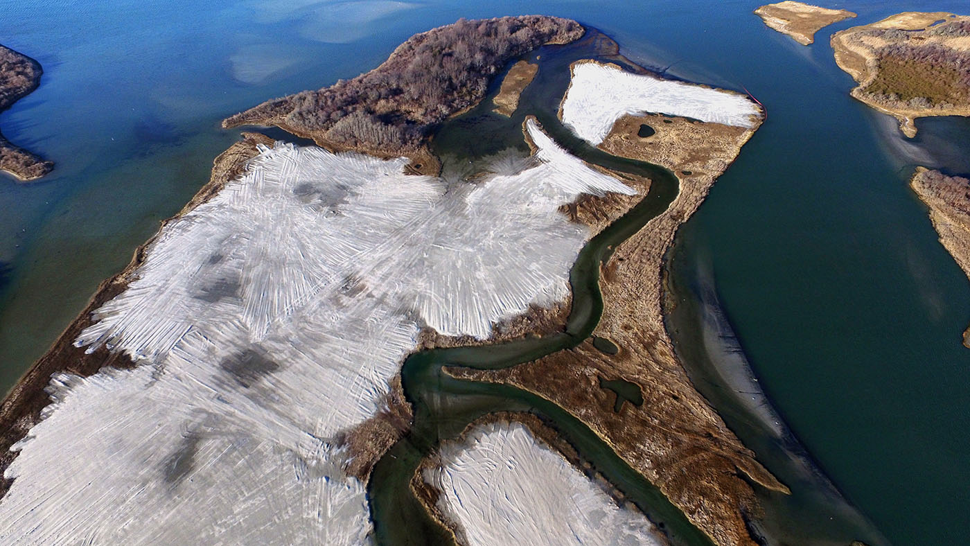
An aerial photo taken of the Ninigret salt marsh immediately after the elevation enhancement work was completed (photo courtesy of JF Brennan)
The CRMC completed a successful and high-profile habitat restoration and elevation enhancement of approximately 30 acres in the Ninigret salt marsh in 2016 and 2017, and has continued to monitor the movement of sediment, growth of native marsh plants (both naturally re-seeded and planted by hand), and tidal flushing. It is embarking on a sister project this fall in Quonochontaug Pond, with the goal the same: to improve the elevation of the degraded salt marsh areas so that it can keep pace with rising sea levels, storm events, and erosion. These coastal areas provide habitat value for fish and other aquatic species, nesting and nursery habitat for birds including the salt marsh sparrow and willet, and add to the scenic beauty that people flock to during the summer months.
Chaffee estimated that the marsh degradation seen at Ninigret took place during the last 15 to 20 years; prior to the restoration, signs of degradation included stunted and dying vegetation, areas that were largely unvegetated, covered in thick algae and permanently flooded with shallow water. These conditions gradually worsened toward the southern portion of the project site.
“The northern part we were putting sediment on vegetated marsh, although it was degraded and beginning to die off, and in the southern part we were basically putting it on dead, bare areas,” Chaffee said.
Compaction of sediments in salt marshes is something that was accounted for in the Ninigret project, as well as estimates for the soon-to-be-started Quonnie project, Chaffee said. Engelhart agrees that for “thin layer deposition” projects, it needs to be a focus.
“The peat, as long as it stays wet, does not compact. But once you add things (like sand), compaction does happen,” he said. “Are we making things worse? We’re trying to answer that at Fox Hill.” It’s clear from his research at the Fox Hill site in Jamestown that from overwash deposits from storm events, compaction is happening. The question of whether adding sand to the peat layer is hurting it is still an unanswered question, Englehart and Chaffee said.
“That’s a huge concern, a little less so in these area marshes, which don’t have a thick peat layer and developed on sand washover areas,” Chaffee said. “We wanted to try to account for that in some way so we took bulk density measurements of the marsh material and translated that into a compaction factor. This is not thin layer deposition – we were putting up to a foot of material in some places. It’s going to be one of the things we’re looking at with the monitoring: how much compaction did we see?”
Wenley Ferguson, director of habitat restoration at Save The Bay and a frequent partner in these and other habitat restoration projects in Rhode Island admits that while the elevation enhancement technique is considered a radical one, the reasoning for going to such measures is clear.
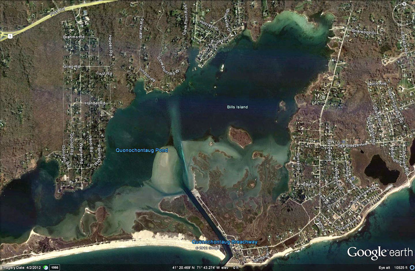
An aerial image of Quonochontaug salt marsh, which will be the site of another CRMC habitat restoration and elevation enhancement project in fall of 2018 (image courtesy of the Town of Charlestown)
“Salt marshes form the base of the Bay’s food web and are critical to the ecological health of Narragansett Bay,” she said in a recent Save The Bay Tides article. “They serve as nurseries and safe havens for many fish, shellfish and bird species to breed and grow, from egrets and saltmarsh sparrows to mumichogs and blue crabs. They filter pollutants and absorb excess nutrients, and during storm events, they can lessen coastal erosion by reducing wave energy.”
In addition to the restoration projects themselves, the CRMC has undertaken more long-term efforts with partners like Save The Bay, the Rhode Island Natural History Survey, and the Narragansett Bay Estuary Research Reserve, as well as other state and federal agencies. Earlier this year, the CRMC released its Rhode Island Coastal Wetland Restoration Strategy, a “to-do” list of actions for managing threatened coastal wetland habitats across the state. Through its R.I. Shoreline Change Special Area Management Plan (Beach SAMP), the CRMC developed the Sea Level Affecting Marshes Model (SLAMM), a mapping and planning tool used to model the state’s coastal wetlands.
According to the maps, Rhode Island is poised to lose 13 percent of its marshes with one foot of sea level rise; 52 percent of marshes with three feet of sea level rise; and a staggering 87 percent of its marshes with five feet of sea level rise. The RI SLAMM maps are being used to investigate areas where coastal marshes are likely to migrate inland and identify undeveloped tracts of land for unimpeded marsh migration. In 2012, 2013 and 2016, Save The Bay led a rapid-assessment survey of 44 salt marshes throughout the state to document marsh degradation, with the cooperation of the CRMC and others.
“The reality is that many of our existing marshes will transition to open water in the coming decades as sea levels continue to rise, but for other marshes and the species that depend on them, adaptation may buy some time – to move inland, that is,” Ferguson said. “We cannot stop sea level rise, but we can help protect areas for our precious salt marshes to migrate inland.”
Stedman Government Center
Suite 116, 4808 Tower Hill Road, Wakefield, RI 02879-1900
Voice 401-783-3370 • Fax 401-783-2069 • E-Mail cstaff1@crmc.ri.gov
![]()
![]()
An Official Rhode Island State Website