![]()
![]()
![]()
![]()

RI Coastal Resources Management Council
...to preserve, protect, develop, and restore coastal resources for all Rhode Islanders
![]()
![]()
![]()
![]()
...to preserve, protect, develop, and restore coastal resources for all Rhode Islanders
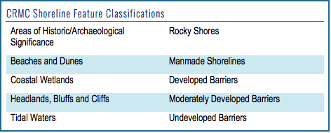
In addition to municipal zoning conditions, properties in coastal areas are subject to coastal zone management classifications that may carry building and permitting ramifications. These classifications are based on both the water the property abuts and characteristics of the shoreline on or near the property.
Coastal or shoreline features such as coastal barriers, dunes, and wetlands have specific regulations and protections under the CRMC. These regulations include structural setbacks, buffers, and rules pertaining to construction and renovating or remodeling older structures. Depending on the property's proximity to coastal features, there may be implications for new construction, home improvements, and structural alterations.
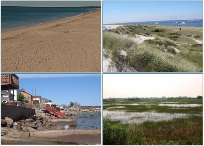
Examples of shoreline features in Rhode Island (clockwise from top left): coastal beach, coastal dunes, coastal wetlands, and shoreline protection structures along a manmade shoreline.
For freshwater wetlands, the R.I. Department of Environmental Management has jurisdiction – to determine whose jurisdiction the property is under, you can check the CRMC/RIDEM Wetland Jurisdiction Maps. For more information about freshwater wetlands management, please see the DEM’s Wetlands FAQ.
Why it matters: A CRMC permit is required for any construction or alteration activity on a shoreline feature or within 200 feet of a shoreline feature. Additionally, setbacks are required for all new structures along the shore. The minimum setback from coastal features is 50 feet, but in areas with erosion, setbacks are determined using the rates of change found on the shoreline change maps (see below).
Distances for setbacks are 30 times the calculated average annual erosion rate for less than four dwelling units, and 60 times the average annual rate for commercial, industrial, or more than four units. Note: Setbacks and buffers are always measured from the most inland edge of the shoreline feature. If there is a coastal buffer zone, an additional 25-foot setback is measured from the inland edge of the buffer zone. (Coastal Buffer Zone: a land area adjacent to a coastal feature that is vegetated with native shoreline species and acts as a natural transition zone between the coast and adjacent upland development.)
For example, if the erosion rate is 2.5 feet per year, and you are planning to build a single-family home, the setback from the inland edge of the coastal feature would be 75 feet (2.5 feet x 30 = 75 feet).
Setbacks that are larger than these requirements will provide the property with a greater level of protection against the impacts of coastal erosion and other hazards.
To identify the shoreline features and find out more: The CRMC’s Guide to Coastal Shoreline Features will help you begin to identify the shoreline features on the property. Additionally, you can consult with CRMC staff for shoreline feature verification and applicable setback requirements. For more information about setbacks and shoreline features, please see Sections 140 and 210 of the CRMC regulations.
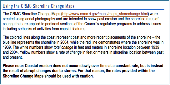
The CRMC’s shoreline change maps depict past coastal erosion, and include the calculated rates of change used to determine setbacks. When siting for coastal construction, the CRMC recommends that property owners exceed the minimum setback requirements in order to better protect the structure, as shoreline change is an ongoing process influenced by coastal storms.
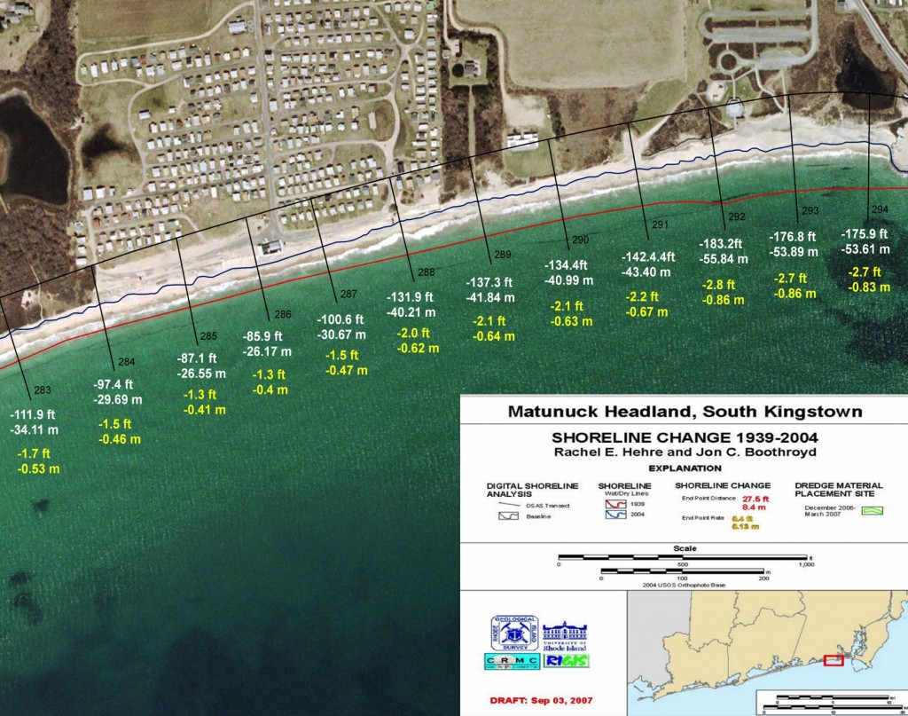
CRMC Shoreline Change Map for the Matunuck Headland in South Kingstown, R.I.
All coastal waters in Rhode Island are categorized into six water types according to the characteristics of the adjacent shoreline, water use, and density of use. Conservation, recreation, transportation, and industrial activities all occur along the shore, and influence the shoreline policies and regulations based on water types. The six water type classifications, as designated by the CRMC, are:
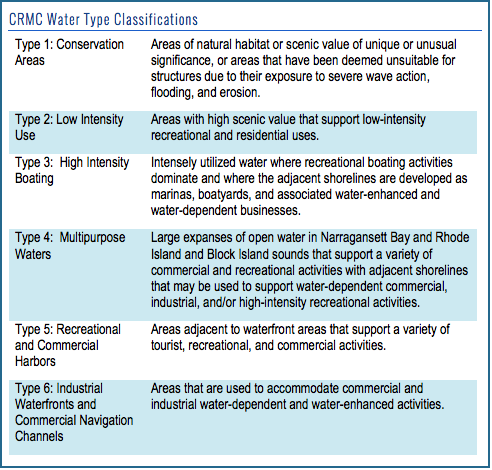
Why it matters: Though all areas along classified waters are subject to coastal zone management, properties located along certain water types may have more strict regulations for development. Some of the activities or structures that are regulated in the coastal area include:
Filling, removal, and grading along the shoreline
Construction of residential or recreational structures, including docks
Construction of public infrastructure
Individual sewage disposal systems
Installation of shoreline protection structures
Beach nourishment (replenishment)
Prohibition of new construction on undeveloped barriers
Identify the adjacent water type and find out more: For each coastal municipality, maps of water types and other shoreline classifications are available online. Information about restricted activities, prohibited activities, and permitting processes can be found in the CRMC regulations.
Some coastal areas are governed by CRMC Special Area Management Plans, and as such, have area-specific regulations. To determine if the property is included under a Special Area Management Plan, visit the CRMC SAMP page.
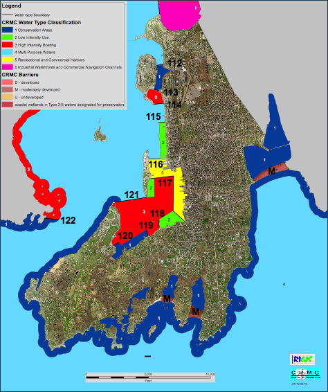
The CRMC Water Use map for the City of Newport, Rhode Island. The water use maps show the six different water types, or classifications, as determined by CRMC along Rhode Island’s coast. Maps for all of the coastal municipalities are available here.
Stedman Government Center
Suite 116, 4808 Tower Hill Road, Wakefield, RI 02879-1900
Voice 401-783-3370 • Fax 401-783-2069 • E-Mail cstaff1@crmc.ri.gov
![]()
![]()
An Official Rhode Island State Website