![]()
![]()
![]()
![]()

RI Coastal Resources Management Council
...to preserve, protect, develop, and restore coastal resources for all Rhode Islanders
![]()
![]()
![]()
![]()
...to preserve, protect, develop, and restore coastal resources for all Rhode Islanders
CRMC adopts Beach SAMP
July 5, 2018, Providence - PROVIDENCE – The State of Rhode Island now has a roadmap to plan for impacts to homes, businesses, and vital infrastructure as a result of climate change-driven erosion, increased storms, and flooding from sea level rise: the newly adopted Rhode Island Shoreline Change (Beach) Special Area Management Plan, the only one of its kind in the nation.
With its June 12 adoption of the Beach SAMP, the R.I. Coastal Resources Management Council (CRMC) now has eight tailored regional plans that span most of the state, providing customized guidelines and regulations for addressing the specific needs of those areas. This SAMP seeks to address Rhode Island’s constantly changing shoreline, and provide tools and guidance to our 21 coastal communities that are on the front line of sea level rise impacts.
“Nowhere else in the U.S. is there a management plan for tackling the complicated impacts associated with sea level rise, and Rhode Island is in a unique position to be a leader,” said CRMC Executive Director Grover Fugate. “Here in the Northeast we are particularly susceptible to sea level rise impacts, and we’re already seeing the effects of climate change in increased, more intense storms, accelerated erosion of our coastline, and damage to our infrastructure. This SAMP aims to provide tools to plan for the future.”
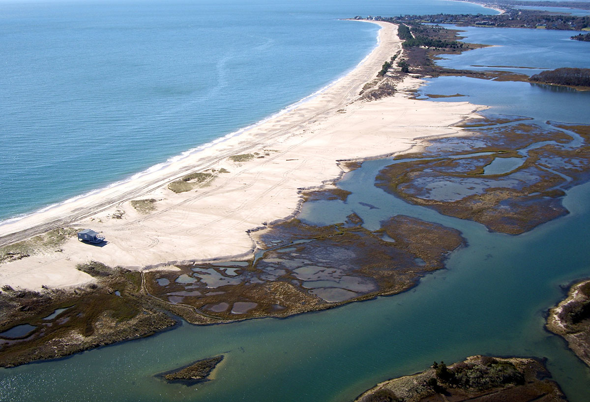
Aerial view of Quonochontaug barrier and Pond after Sandy
Rhode Island’s 420 miles of coastline is one of its most iconic and treasured assets. The variety of shoreline types – from the historic waterfronts of Newport and summer communities of Matunuck, to the barrier beaches of Napatree, southern coast salt marshes and bluffs of Block Island – define the Ocean State and provide the recreation, income, and economy that is unique to our state.
These shorelines are quickly changing as a result of natural forces brought by climate change, and Rhode Islanders are experiencing the impacts: storms erode beloved beaches and damage homes and businesses, and flood neighborhoods and damage vital roads; rising seas gobble up once-dry land on a more frequent basis, and impact drinking water supplies.
In order to help our communities protect people, property, and infrastructure, and to ensure smart decision-making based on the best science in light of these and future impacts, the CRMC and its partners, the University of Rhode Island and its Coastal Resources Center, Rhode Island Sea Grant, state and municipal partners, non-governmental organizations, stakeholders and coastal residents, have developed a SAMP spanning the entire coastline of Rhode Island.
Over the past five years, the CRMC has developed a guidance document and a suite of tools for state and local decision-makers to best prepare for, absorb, recover from and adapt to the impacts of storms, erosion, and sea level rise.
Tools
STORMTOOLS is an online mapping tool that shows storm surge and sea level rise scenarios for the entire coastline. One of the challenges facing state and local planners was the lack of an objective, defined assessment of risk to structures (homes and businesses), infrastructure , and public safety services that comes from storm impacts in these changing conditions. STORMTOOLS provides scenarios for a multitude of situations (1 foot of sea level rise, up to 9, with or without storm surge, with or without hurricane conditions).
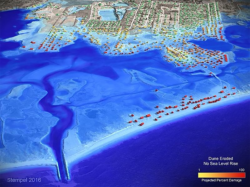
CERI map showing damage to structures in a storm and flooding scenario (Courtesy of URI)
The Coastal Environmental Risk Index (CERI) was developed to predict storm surge and wave height in different storm scenarios, combined with shoreline change maps showing erosion, and damage functions to construct a risk index to structures. CERI and STORMTOOLS are already being utilized by coastal municipalities. Click here for information on both tools - http://www.crmc.ri.gov/samp_beach.html.
The Rhode Island e911 exposure assessment offers a summary of all exposed structures in each of the 21 coastal communities in Rhode Island under a variety of coastal flooding scenarios: from twice-daily tides based on sea level rise projects out to the year 2100; and from coastal storm events with and without sea level rise scenarios. Find that data here - https://stormtools-mainpage-crc-uri.hub.arcgis.com/e911/.
CRMC’s Sea Level Affecting Marshes Model (SLAMM) maps show how coastal wetlands will likely transition and migrate onto adjacent upland areas under projected sea level rise scenarios of 1, 3, and 5 feet. These maps – there are maps for all 21 coastal communities – are intended to support state and local community planning efforts and to assist in preparing for and adapting to future wetland conditions despite the inherent uncertainties with future sea level rise. Find those maps here - http://www.crmc.ri.gov/maps/maps_slamm.html.
An important printed tool is the Coastal Property Guide, which offers steps homeowners and businesses can take to protect their coastal property from storm flooding and shoreline erosion. The 30-page guide contains information about the unique conditions property owners face on the coast. The information is provided in 10 sections and covers a range of topics from setbacks to septic systems. Click here for a downloadable electronic version - http://www.beachsamp.org/relatedprojects/coastalpropertyguide/.
MyCoast Rhode Island is an online reporting tool that provides real-time tidal, storm, and shoreline monitoring data and images to coastal managers, including the CRMC. Information on the site, which was developed by the CRMC, URI CRC, RI Sea Grant, and Save The Bay, is used to demonstrate the impact of coastal hazards. MyCoast users can upload storm or tide event photos and tag their locations and current conditions via an app, and the information is stored on the site. Go to https://mycoast.org/ri for more information.
This information is going to also be critical in the recently filed lawsuit against 21 of the largest fossil fuel companies by the R.I. Attorney General Peter Kilmartin. Announced at a press conference on July 2, Kilmartin cited the information collected in the Beach SAMP development as being necessary as the lawsuit proceeds.
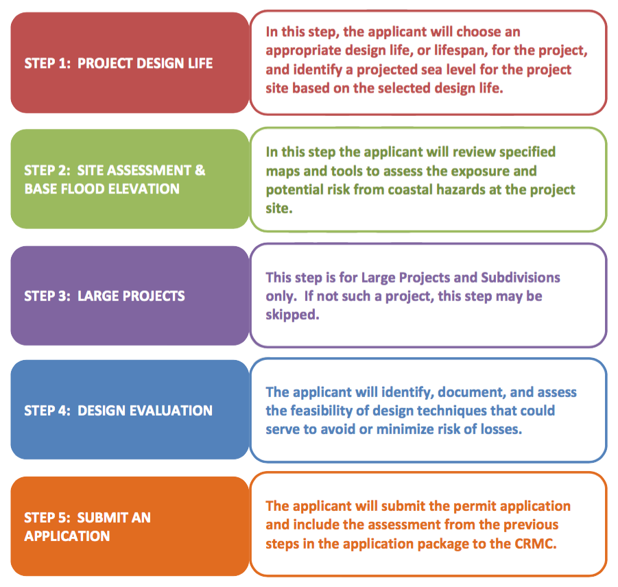
Chapter 5 permitting process
The SAMP document
The innovation of the Beach SAMP lies in its coastal permitting process. Chapter 5 – RI CRMC Coastal Hazard Application Guidance – presents a unique, five-step process for applicants to consider the impacts of current and future coastal hazards. The goal is to ensure that CRMC-approved projects are designed and built with the applicant’s acknowledgement of the risks associated with building in coastal hazards areas exposed to storm surge, erosion, and future sea level rise conditions.
This process will also help protect public health, safety, and welfare; minimize damage and losses to nearby infrastructure and properties; and reduce overall impacts to coastal resources. Adapting to these ongoing and future conditions will ensure Rhode Island is building resilient communities, as well as a strong coastal economy and environment.
“Instead of simply building to today’s coastal conditions, as virtually every other regulatory program requires, this process for development will take into account those future conditions, and allow for building to them,” Fugate said. “We’re at the forefront with this unique guidance. The goal is to educate homeowners and property owners, get them to understand their risk in terms of the life of their structure. It’s a big step forward in getting people to understand that they will have to deal with these issues likely within the life of their 30-year mortgage.”
Stedman Government Center
Suite 116, 4808 Tower Hill Road, Wakefield, RI 02879-1900
Voice 401-783-3370 • Fax 401-783-2069 • E-Mail cstaff1@crmc.ri.gov
![]()
![]()
An Official Rhode Island State Website